Introduction
The goal of the project, is to be able to perform persistent tracking of acoustic fish tags through combining sensor readings from multiple vessels through multilateration. To further break this down, a scenario of the type of mission is given below.
| # | Mission Phase | Description |
|---|---|---|
| 1 | Transport | Bring the equipment to the deployment area. |
| 2 | Deployment | Assemble and prepare the vessel. Ensure supporting systems (Server/Operator console) are running. Launch vessels. |
| 3 | Travel to search area | Vessels travel from deployment area to search area. |
| 4 | Collaborative search | Search area is divided between vessels. Ends after first tag detection. If first search yields no result, perform predetermined action, like searching again or extending search area. |
| 5 | First tag contact | First contact with acoustic tag. The detecting vessel waits or tries single vessel tag positioning. Other vessels congregate to its vicinity, entering formation. |
| 6 | All vessel tag contact | Enter tag formation to commence collaborative fish tracking. |
| 7 | Collaborative fish tracking | Keep formation around tag to estimate its position. |
| 8 | Tracking end | Mission finished or battery level low – wait for pickup or return to predetermined point (like deployment point). |
| 9 | Berthing/ Dismantling equipment | Removing the vessel from the water. |
| 10 | Transport | Pack up equipment and leave deployment area |
Collaborative Fish Tracking
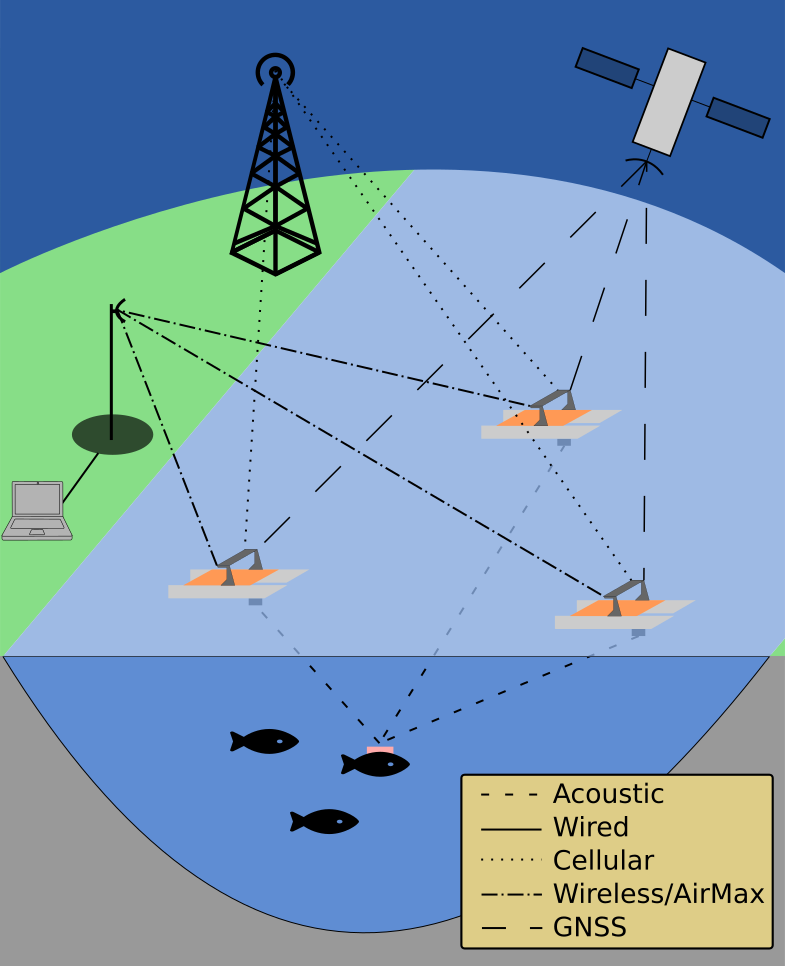
 A visual representation of the most important phase of the scenario, the fish tracking,
is shown in the figure. Here, the three Fish Otters have gained contact with a tagged fish,
and is using multilateration to estimate its position. Based on the estimate, decisions are
then made regarding the next position of the formation. The formation also has to try to
minimize GDOP, while at the same time avoiding surrounding hazards and reducing the
thruster usage. Reducing motor usage is beneficial because it conserves the stored energy
and reduces noise in the medium (water). Increased noise makes it harder for the acoustic
receiver to discern tag transmissions and may also influence the fish behavior.
The communication between the operator and the vessels, can, as shown in the figure go through two channels: the public cellular network, and the private Ubiquiti AirMax network. Either one, or both at once is to be used, with the expectation that bandwidth and increased network control will be benefits of the AirMax channel, while range is the benefit of the cellular communications.
Positioning of the vessels is based on GNSS systems, which also is a multilateration system. The GNSS can be used as an inverted analogy for the fish tracking performed by the Otters. In the GNSS, the satellites transmit signals, with the Otters receiving them. In the fish tracking scenario, the Otters have the same role as the satellites, but instead receives the message sent from the acoustic tag for surveillance purposes.
